
NOAA Coast Survey: free PDF charts, improved RNCs, nautical charts
The Nation's Nautical Chartmaker Since 1807
*** Things are changing for NOAA nautical charts
By now, most people have heard the news about the end of lithographic nautical charts, effective April 13, 2014. (See
NOAA announces end of traditional paper nautical charts.) While media and bloggers covered the announcement quite effectively, less noticed was the fact that mariners will still be able to purchase paper nautical charts, in the form of up-to-date NOAA-certified Print-on-Demand (POD) charts.
The announcement also indicated that Coast Survey is exploring new opportunities for private companies to fill market niches in the constantly evolving world of navigation. Within a week of the announcement, half a dozen companies had contacted Coast Survey, indicating an interest in the Print-on-Demand partnerships. The time seems to be exactly right for the privatization of printing and selling NOAA's nautical charts.
Free PDF nautical charts now available
We also announced that our latest addition to the nautical charting portfolio is the new Portable Document Format (PDF) nautical chart, which provides up-to-date navigation information in this universally available file type. Initially, the PDF nautical charts will be available for a three-month trial, from October 22, 2013, to January 22, 2014.
For the trial period, Coast Survey is providing about a thousand high-resolution printable nautical charts -- almost the entire NOAA suite of charts -- as PDF files. The PDF nautical charts, which are almost exact images of the traditional charts currently printed by lithography, are free.
(Read more at NOAA nautical charts now available as free PDFs.)
Better RNC images coming
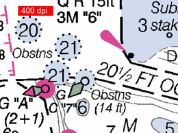
Earlier this week we announced some good news for boaters with electronic charting systems that use NOAA raster navigational charts (NOAA RNC®): charts are going to be easier to read. Cartographers at Coast Survey are busy improving the resolution of NOAA RNCs, increasing the chart images from the current 254 dpi to 400 dpi.
 |
 |
| Current RNC image |
Improved RNC image |
A little explanation... The NOAA RNC is a geo-referenced digital image of the traditional paper chart. When it comes to digital graphics, higher resolution is generally better than lower resolution. Dots per inch (dpi) measures the image resolution: the higher the dpi, the better the resolution, the clearer the image. Increasing dpi to 400 improves the clarity, readability, and aesthetics of this highly popular digital charting product. The change is being phased in for all 1000+ RNCs, finishing up by January.
(Read more at Better nautical chart images coming to electronic charting systems.)
More announcements soon
Technology is moving fast, and mariners expect and deserve navigational products that harness technological advancements to provide the most up-to-date information. Coast Survey continues its 200-year commitment to providing the products and services that keep mariners safe and commerce moving.
Watch your email (and subscribe to the NOAA Coast Survey blog) for announcements about other new services, coming soon.
------
*** President Obama appoints Coast Survey director to Mississippi River Commission
On September 19, President Obama appointed Rear Admiral Gerd Glang, director of the Office of Coast Survey, to the Mississippi River Commission. RDML Glang was sworn in as an MRC commissioner by National Ocean Service Assistant Administrator Holly Bamford. He has been serving as a member-designee of the commission since becoming the director of Coast Survey.
NOAA flag officers have long represented NOAA on this vital commission, but this is the first time in two decades that the officer is assigned to the National Ocean Service.
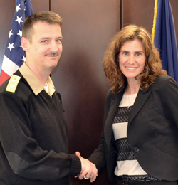
NOAA NOS AA Holly Bamford congratulates Rear Adm. Glang after swearing
him in as commissioner of the Mississippi River Commission
------
*** New edition of Chart 11370 aids river pilots
Coast Survey recently issued a new edition of Chart 11370, Mississippi River - New Orleans to Baton Rouge. The new edition features significant revisions to all charted revetments and anchorages, and updates the shoreline.
Since significant infrastructure damage can occur when anchorages conflict with revetments, Coast Survey cartographers spent nearly six months in discussions with the U.S. Coast Guard and the Army Corps of Engineers to sort out charting conflicts. With the new edition, river pilots will find it easier to anchor in areas that do not overlap with revetments.
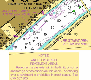
Chart 11370, Edition 29
Chart 11370, Edition 29, is now available as Print-on-Demand, NOAA RNC®, and PDF nautical chart. Printed lithographic charts have been delayed because of the government shutdown. Corresponding ENCs US5LA51 and US5LA52 should be posted by the end of November.
TOP
|