
NOAA Ship Rainier completes year's surveys, heads home to Newport
NOAA Ship Rainier is due to arrive at its homeport in Newport, Ore., on November 1, completing the ship's 2012 hydrographic survey season. This survey season, Rainier departed Newport on May 17 and spent her summer mapping 604 square nautical miles of the ocean floor in Alaska, stretching from Kodiak to the Shumagin Islands, along the Alaskan archipelago.
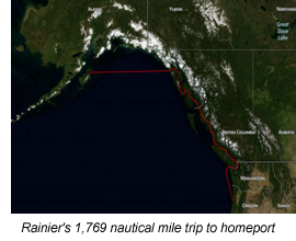
"We completed our last survey on October 24, and began the long 1,769 nautical mile trip back to Oregon," said Rainier's commanding officer, Cmdr. Richard Brennan. "The crew put a lot of great effort into their work, some of it under challenging weather conditions."
Rainier and her four smaller survey vessels use multibeam echo-sounders to measure the depth of the ocean along her path, collecting millions of measurements. More than half of the area surveyed by Rainier this summer had never been surveyed before, leaving large sections of nautical charts void of ocean depth measurements. Commercial shippers, passenger vessels, and fishing fleets need updated charts, which NOAA's Office of Coast Survey will produce with the multibeam's precise and accurate measurements.
"Simply put, we have better maps of the moon than of our oceans," said Rear Adm. Gerd Glang, director of Coast Survey. "Much of our knowledge of U.S. coastal seafloors dates from eras when ocean commerce was more limited, especially in Alaska."
 At a time when Alaskan waterways are facing unprecedented demands from maritime commerce, Rainier is acquiring the data for navigational charts that are the foundation of the marine transportation system, Glang explained. At a time when Alaskan waterways are facing unprecedented demands from maritime commerce, Rainier is acquiring the data for navigational charts that are the foundation of the marine transportation system, Glang explained.
he 231-foot Rainier, one of the most modern and productive hydrographic survey platforms of its type in the world, is named for Mount Rainier, a massive volcanic cone rising 14,410 feet above sea level in Washington. At the time the ship was commissioned, in 1968, vessels of this class were named for geological features. Rainier underwent a major repair period from Nov. 2009 to Jan. 2011, when new systems and equipment were installed.
The ships sophisticated seafloor mapping systems allow researchers to acquire hydrographic data that is used to update the nations nautical charts. Rainier carries four survey launches that survey shallow, near-shore waters.
Rainiers scientists, survey technicians, NOAA Corps officers, and crew bring a wide range of navigational and hydrographical expertise to the mission. Rainier has a total complement of 52 people: 12 NOAA Corps commissioned officers, 11 engineers, 14 deck/boatswains, 9 hydrographic survey technicians (in addition to the officers, who are all hydrographers), four stewards, and two electronic technicians.
For updates on navigation response to Sandy, or to read earlier posts on the response, check the NOAA Coast Survey blog.
TOP
|