|
In the northern arc of the Big
Lake lies a wilderness stretch of islands and water that may be sailing's
best-kept secrets.
Verdant islands rise up majestically from blue waters, and, wonder of
wonders, there are island harbors into which you can wriggle your boat for
the night. In some of the better-known anchorages, such as Loon Harbor,
you might actually see another boat. But in an entire day of cruising,
seeing another boater out on the water is a rarity, rather than
commonplace.
The area stretches from the tip of the Sibley Peninsula, overlooking
Thunder Bay, Ontario, to the incredible Slate Islands. It's so special
that the Canadian government plans to make 11,000 square kilometers (about
one-seventh of the lake) into the Lake Superior National Marine
Conservation Area (NMCA). This will be the largest marine conservation
area in the world.
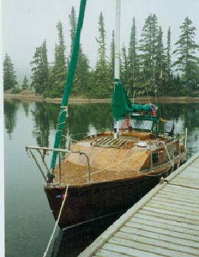
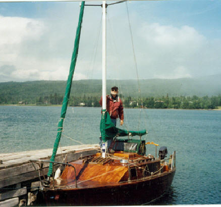
In 1999, I sailed this area from west to east. For one remarkable month, I
piloted my 20-foot centerboard sloop, Persistence, through tiny island
chains, quiet channels, and out onto the open waters of mighty Superior.
It was a prime wilderness cruising experience that is open to most serious
boaters. The wonder is that more adventurous sailors don't try it.
Getting the northern mindset: The area I'm talking about - the northern
arc of Lake Superior - lies in Canadian waters. It's a different kind of
cruising up there, and, for the most part, both challenging and enjoyable.
It is for the experienced cruiser, who has blue water or Superior storm
experience, and who has a well-found boat that is well prepared and in top
operating condition.
It's different than, say sailing the Apostle Islands, or, the Duluth -
Superior harbor. Where you are going you will be on the open waters of
Lake Superior, and, into a wilderness island area. You will need to be
dependent upon your own resources. If something breaks, or if you run low
on gas or drinking water, there 's no handy marina to pull into. You will
be on your own.
Will your boat take it? In general, your boat should be larger than 20
feet LOA and have a self-bailing cockpit. Ideally, it should be a
well-built keelboat, which the manufacturer has designated as a coastal or
blue water cruiser. Lightly built sloops are not for Superior, which more
resembles an inland ocean than a lake, nor for wilderness exploring, since
there are some reefs to bump into from time to time. In my own northern
arc passage, I ran aground once at Swede Harbor, touched bottom going up
Nipigon straight, hit my centerboard hard coming into a private dock in
Rossport Harbor, and went fully up on rocks and had to be pulled off
trying to enter CPR harbor. The boat suffered no major damage.
I saw a variety of sailboats in the wilderness - not many, but a
variety-ranging from a massive full keel 35-foot Baba cutter to a bright
finished 45-foot Vic Carpenter Orenda, with deep fin keel. From my own
personal observations, my own boat was the smallest sailboat out on the
big lake: a well-built 20-foot custom epoxy wood veneer centerboard sloop.
It goes without saying that your boat should be in its top operating
order, with no weaknesses, and, fully equipped with all the water, stores,
supplies and food that you will need for the duration of your wilderness
cruise, with about a 50 percent reserve.
Canadian, eh? You are entering Canada and you will need to observe the
formalities of this friendly neighbor to the north in which you are a
guest. For sailors, they've made it fairly easy.
If you are sailing across the border into Canada, it's useful to apply to
Canadian Customs in advance for a Remote Area Border Crossing Permit,
(sometimes called a Canpass) to go cruising. This Permit allows you enter
Canadian waters without first reporting to an official port of entry
(Sault Ste Marie and Thunder Bay).
It's a good idea to check in with the helpful Thunder Bay Coast Guard
(TBCG.) Before you set sail each morning, contact the TBCG via your VHF to
file your daily Sail Plan. In the wilderness, this is your lifeline. If
you are wondering how your VHF can reach Thunder Bay, you should know that
the TGCG has radio repeaters all along the rugged, high bluffs of the
northern coastline.
I recommend full-power VHF with a high antenna mount to get the range
you'll need for this vital lifeline.
Getting up there: From the east, big boats can enter Superior through the
Sault Ste Marie Locks and set sail westward. I've passed through these
locks myself in a 35-foot catamaran, Tulamore Dew (owned by Joe Boland and
with Northern Breeze's Thom Burns onboard) and, it's not a big deal. Bring
long lines to handle the boat as the water level is changed.
Boats on other areas of Superior can simply sail over. You should have a
Remote Area Border Crossing Permit to do this so you don't have to report
to a port of entry.
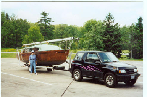
Smaller boats can be trailered up, and, launched at several different
locations:
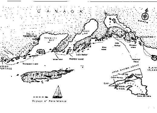
*A few miles south of the border, you can launch at Grand Portage, MN
(home of an old voyageur fur fort). I launched at the old Voyageur Marina,
on the eastern side of bay, near Hat Point. But not all sailboats can
navigate this rock-strewn harbor.
*Across the border, you can launch at the well-equipped Prince Albert
Marina in Thunder Bay. From here you head southward on Thunder Bay to the
tip of the Sleeping Giant Mountain and then voyage eastward.
* Further east, you can launch in Rossport, Ontario, a sleepy little
fishing village nestled beside one of the mainland's most beautiful
harbors. From there you can head out Schreiber Channel, past the wreck of
the Guinilda (one of the best preserved millionaire's yachts in the world,
Jean Michelle Cousteau once told me) and, out to the Slate Islands. From
there, you can work your way westward, ending up at Thunder Bay.
Bring warm gear: This is the North Country. On the 4th of July, in Grand
Portage harbor, I was shivering and I could see my breath inside my cabin.
I was cold despite the fact that I was wearing heavy winter long johns,
wool socks, and fleece. For my feet I had an old sheepskin to put on my
wood floorboards.
In addition to chilly nights, you can expect other wilderness weather:
thick fog - I mean thick fog - driving rain, wild winds, and, in my case
an unpredicted windstorm. The water you're boating in is always cold -
around 46 degrees at the surface, and, just a few degrees above freezing
year at the thermo cline.
But also look for picture postcard days with bright sun and fleecy clouds
in bright blue skies. In other words, the weather changes. A lot.
Weather forecasts: On Superior's northernmost arc, where the weather is
always a battleground, you can't entirely rely on the accuracy of the
radio forecasts, often made many miles away. As one Canadian boater told
me in CPR harbor: "If you listen to them (the Canadian weather service),
they'll scare you to death - and you'll never go anywhere." I listened to
him, and, ran into horrific fog and sloppy waves that sloshed up through
my open centerboard trunk and into my cabin.
Navigation: Up-to-date Canadian charts are a must (see suggested list.)
It's wise to keep a full set because, frankly, you never know when you'll
encounter heavy weather and need to duck into that out of the way harbor,
or, behind that little island.
You'll need a cruising guide and for my money, Bonnie Dahl's, the Superior
Way (3rd edition) is indispensable. This former schoolteacher is a devoted
Superior cruiser and her book shows the way into many little harbors not
shown in official Canadian charts, has a number of useful drawings, and
important GPS waypoints. It also tells where some of the rocks are, and,
ways around most of them.
A GPS is mandatory, as well as the ability to use it well and swiftly. The
hand-held is especially useful since you'll want to keep it close - very
close - when you encounter fog or bad weather.
Compasses are essential but you should know that some rocks up there are
magnetic and can throw you off as much as 20 degrees. I mostly used my
GPS, with the compass as a backup. A depth sounder is useful, also, for
finding your way through rock-strewn areas before your built in depth
sounder (your keel) is called into play. Radar becomes valuable when you
get caught out in cotton-wool fog - as I did. I did not have a radar set,
and, I began laying in GPS waypoints like crazy, charting my way through
sudden fog and high waves off the open waters and up Simpson Channel
toward Nipigon Bay, heading toward Rossport. My trusty hand-held GPS, with
accurate Canadian charts, saved the day.
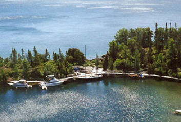
Highlights: Guarding the mouth of Thunder Bay, Thompson Island is blessed
with a large bluff overlooking a small harbor, which is favored by Thunder
Bay boaters. I was surprised when I first pulled into this harbor, for
though it is officially designated as "Crown Land" it had a wonderful
rustic dock, with patios overlooking the harbor, and a nice sauna (After a
day on chill waters, you'll come to love saunas as much as the canny
Canadians.) Some boaters rate Thompson Cove as a must-see.
In the shadows of Sleeping Giant Mountain, off the Sibley Peninsula, lies
the sleeping little hamlet of Silver Islet. The docks are scoured and worn
from ages of ice, but I fixed myself a camel to protect my hull. Up on
shore is a refurbished General Store, and beyond, rusting mining
machinery. This was once a boomtown based on the incredible discovery of
silver at an island just a few clicks out on Superior - and once the
world's richest silver mine. Watch the weather, for if you are caught - as
I was - by winds from the east, you can have long rollers coming right
through the breakwaters and bumping your boat against the dock. It was a
rough night.
Shoving off from Silver Islet, you are in the proposed Lake Superior NMCA,
and you'll be entering a gorgeous chain of islands to the east. Accurate
charting, and use of GPS waypoints is a must, however, to find the
entrance to the little natural harbors. One of the beautiful harbors along
this route, and a fitting ending to a day's sail, is beautiful Loon
Harbor. You'll find good anchorage here. I double-anchored (always wise on
Superior) in the eastern end.
|
|
You are now in
an archipelago of islands covered with spruce and firs, probably as
untouched as when the voyageurs made their way across the northern arc
centuries ago. In fact, on some of the islands are "pits," which may have
been created by voyageurs and by the Native Americans who canoed this
area. Glance northward to the rugged Ontario shoreline - some bluffs soar
a thousand feet high.
Heading eastward again, there are many little islets and harbors to choose
from. Here you can easily spend days settling down to enjoy the clear
waters and the fresh air. Don't look for many of these little anchorages
to be shown on the Canadian charts, however - they're too small. To find
them, you need a cruising guide that shows wilderness anchorages and GPS
waypoints to get into them.Along the way, there
are lighthouses, including the Island of Doom, Talbot Island, the site of
Canada's first lighthouse on Superior and the place of haunted tales. Pass
by on a foggy day, and, legends say you still may hear shrieks (though I
did not).
A favorite harbor inside the archipelago is CPR harbor, where I finally
tied up at a small dock. Here I found other boaters, which was lucky, for
on my way past Agate Island (yes, there are agates), I ran aground on some
rocks. After failing to get myself off, including kedging, I made a call
on my VHF and made contact with a boat in CPR harbor, which came out and
pulled me off.
Old Rossport, with its beautiful harbor, is worth a visit and gives you a
chance to catch up on civilization. Though the town is tiny, it has a few
really fine restaurants, including the Rossport Inn, run by my friend, Ned
Basher. Here you can tie up on a good dock and replenish your gas and even
take a shower (for a price).
Shoving off from Rossport through the beautiful islands, you can head out
to the Slate Islands. These were formed millions of years ago by
meteorites striking the earth, and, from afar they rise up like something
out of the movie, South Pacific. There are several good harbors inside the
Slates for you to spend some pleasant nights.
That's a quickie tour of some of the highlights of the northern arc. I
ended my own cruise at the end of the archipelago chain, the Slates, and
then headed back to Rossport, where my wife, Loris met me and we trailered
our boat back to our home in Shoreview, MN.
One thought: in these days of uncertain foreign travel overseas, it's
splendid to have a cruising ground so near, yet foreign and different, and
still so interesting.
Canadian, eh? If you are wondering what it's like to go across the border
in your boat and meet Canadians first hand, be prepared for the most part
to be pleasantly surprised. The Canadian boaters I met in the islands were
some of the most hospitable I've ever met while traveling or voyaging -
outgoing, friendly, and often with a rugged Canadian sense of humor. For
example, when I was weather-bound on one island, the captain and crew of a
large ferro-cement ketch practically adopted me and fed me fish chowder. A
cruising couple invited me to come back to live with them until a weather
window passed (I declined that very generous offer, and, decided to play
Robinson Crusoe on an island).
At an anchorage or in a small island harbor, Canadians regard boating as a
fine social activity. Don't be standoffish, or, on the other hand, overly
brash. Regard yourself not as a stranger, but as a part of a small tribe
of wandering sailors within an overwhelming wilderness, and, assume that
wilderness social rules apply. Join campfire groups, go up to other
boaters, with your cap in hand, to politely introduce yourself or inquire
about your route or the weather. Be prepared to offer generous hospitality
- and this can be very enjoyable. If they like the cut of your jib, you
might be offered a beer or to share a meal. (Hint: take along a goodly
supply of things to socialize with - the Canadian sailors I met regarded
beer as a national beverage. Bud Light was among the preferred labels from
south of the border.)
A good mindset to have is to politely assume friendliness and cooperation
from your fellow boaters. In this northern arc's wilderness, you should be
able to rely on them - and they on you. Up there, one never knows, do one?
Other helpful stuff: To obtain a Remote Area Border Crossing Permit
(sometimes called a CANPASS), write to Immigration, 221 Archibald St. N.,
Thunder Bay, Ontario P7C 343, or call 1-807 964 2093.
To file a Sail Plan either before or as you depart, call the Thunder Bay
Coast Guard by telephone (1-807) 345 4618 or on your boat's VHF. They'll
take down information about you, your boat, and, your passengers as well
as ask you specific sail plan questions. You should know in advance your
destination and your estimated ETA. You should file a Sail Plan daily.
To obtain charts for your voyage into the northern arc of the lake, you
can call various chart services, including West Marine at 1-800-262-8464.
They carry the Canadian Hydrographic charts at about $20 per chart, plus
shipping & handling.
If you are heading out of Grand Portage, MN, you'll need U.S. chart 14968,
Grand Portage Bay, Minnesota, to Shesheeb Point, Ontario. This chart shows
the island chains along the U.S. border from Grand Portage to the mouth of
Thunder Bay. Like Canadian chart 2301, it also covers the Superior area
eastward to Brodeur Island.
Canadian Chart 2301, Passage Island to Thunder Bay, shows the Thunder Bay
area, including the Sibley Peninsula, with Silver Islet. Spar and Thompson
Island are at the westernmost section of the chart; on the easternmost is
Brodeur Island.
Canadian Chart 2311, Thunder Cape to Pigeon River, is a larger scale map
of the mouth of Thunder Bay, giving detail of Thompson Island and Pie
Island.
Canadian Chart 2302, St Ignance Island to Passage Island, moves the
voyageur eastward again, out of the Shagahash Island area (westernmost)
past Spain and Lasher Islands with Loon Harbor, toward St. Ignance Island.
Included in these island chains are Puff Island, Fluor Island as well as
Talbot Island (home of the Lighthouse of Doom). Directly across from Agate
Island is CPR Harbor.
Canadian Chart 2312, Nipigon Bay and Approaches, takes a sailor from Spar
Island (on the east), past the Nipigon Strait and St. Ignance Island, as
far east as Wilson Island. This includes a section of the Schreiber
Channel and Rossport Harbor.
Canadian Chart 2303, Jackfish Bay to St. Ignance Island, includes the
Rossport harbor, detail on the Schreiber Channel, and the Slate Islands on
the east.
U.S. Chart 14960 is a comprehensive chart (scale 1:600,000) of Lake
Superior.
Maptech has a digital chart, ND1 N1, for Lake Superior (Canada).
Bonnie Dahl's Superior Way (3rd Edition) is the preferred cruising guide
and has detailed drawings of various island harbors as well as GPS
waypoints. It may be ordered from a marine bookseller, from an Internet
bookseller, or directly from the publisher, Lake Superior Port Cities,
Inc., at 1-888-BIG LAKE (244-5253). Cost is $39.95.
For information on the proposed Lake Superior National Marine Conservation
area, and color photography of the northern arc, go to
www.parkscanada.gc.ca (click on Lake Superior National Marine Conservation
Area)
To read about a day-by-day account of a voyage through the proposed Lake
Superior NMCA, read Marlin Bree's Wake of the Green Storm (Marlor
Press $13.95) or visit the author's web site, www.marlinbree.com. An
autographed copy of the book is available by calling 1-651-484-4600.
For an on-line marina guide to the northern arc marinas, check out
www.lakesuperiorboating.com. This web site shows dock facilities in major
areas, such as Silver Islet government docks and Rossport, and tells what
services are available at the docks and in the nearby towns. It does not
show the island archipelagoes or anchorages, but is very helpful guide to
specific communities, harbors and marinas along the route.
A color brochure as well as a 28-page Marina Guide is also available from
the North of Superior Travel Association (1-800-265-3951).
You can usually convert U.S. dollars into Canadian dollar at most banks as
well as at various border offices. In a pinch, most Canadians will take
U.S. dollars, but you probably won't get as good a rate. Incidentally, the
rate is wonderful right now: for every $1 U.S., you get back nearly $1.50
in Canadian money.
* * * * * * * *
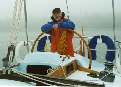
Marlin Bree is a veteran Superior cruiser and the author of three Lake
Superior books: In the Teeth of the Northeaster, Call of the
North Wind, and, Wake of the Green Storm. He built his own
boat, the Persistence.
|