| Northwest
Passage Achieved!
By Roger Swanson and Gaynelle
Templin
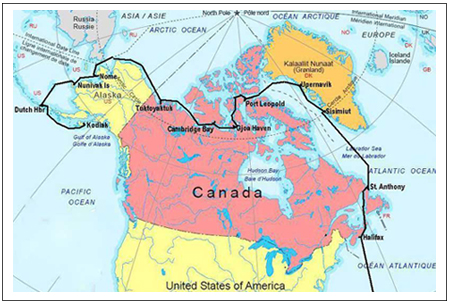 Our
attempt to transit the Northwest Passage aboard
Cloud Nine in 2005 ended when we were turned back
by pack ice in Franklin Strait. At that time I
felt quite confident in saying “Never again”.
This was my second unsuccessful attempt having
been stopped by ice near Resolute in 1994. Two
disappointments were enough. But I remained in
email contact with Peter Semotiuk, a radio operator
at Cambridge Bay located near the middle of the
Northwest Passage. He commented in one of his
letters that the passage had opened for a time
during the summer of 2006. Early in the year Gaynelle
and I wondered if we should try again. We discussed
the question and decided to wait until June to
review the early ice predictions before making
a final decision. Our
attempt to transit the Northwest Passage aboard
Cloud Nine in 2005 ended when we were turned back
by pack ice in Franklin Strait. At that time I
felt quite confident in saying “Never again”.
This was my second unsuccessful attempt having
been stopped by ice near Resolute in 1994. Two
disappointments were enough. But I remained in
email contact with Peter Semotiuk, a radio operator
at Cambridge Bay located near the middle of the
Northwest Passage. He commented in one of his
letters that the passage had opened for a time
during the summer of 2006. Early in the year Gaynelle
and I wondered if we should try again. We discussed
the question and decided to wait until June to
review the early ice predictions before making
a final decision.
On March 6 Gaynelle and I headed
for Trinidad. With friends as crew we planned
to sail to the Virgin Islands and have the boat
ready to head north if we decided to try for the
passage. Our trip was put on hold when Gaynelle
tripped in a restaurant in Trinidad breaking both
wrists. When the local doctor informed us that
surgery would be required, Gaynelle flew home
with a splint on one arm and an elastic bandage
on the other not realizing at that time that the
second wrist was also broken. After arriving back
in Minnesota, Gaynelle spent four hours in surgery
at Mayo Clinic repairing her right wrist.
While Gaynelle was recovering
at home, I sailed Cloud Nine to the Virgin Islands
so it would be ready to go and then returned to
Minnesota to wait. By June the ice predictions
were cautiously optimistic, Gaynelle’s wrists
were healing, and we decided to go for it. On
June 28 Cloud Nine sailed north from the Virgin
Islands headed for Halifax, Nova Scotia, with
a three day R & R (repair and reconstruction)
stop at Bermuda. Gaynelle was not part of our
crew on this passage because her wrists needed
more healing time.
 We
arrived at Halifax and proceeded to the Royal
Nova Scotia Yacht Squadron marina arriving at
0600 on July 12 at Halifax. The RNSYS is the oldest
yacht club in North America being founded in 1837.
The 48 hours preceding our arrival found us sailing
through pea soup fog the entire time. What made
it especially challenging was that our landfall
coincided with the arrival of 135 other sailing
boats completing the Marblehead, Massachusetts
to Halifax race, all of us in fog. It was noon
before we cleared customs, found a mooring, and
had a chance to settle down. We
arrived at Halifax and proceeded to the Royal
Nova Scotia Yacht Squadron marina arriving at
0600 on July 12 at Halifax. The RNSYS is the oldest
yacht club in North America being founded in 1837.
The 48 hours preceding our arrival found us sailing
through pea soup fog the entire time. What made
it especially challenging was that our landfall
coincided with the arrival of 135 other sailing
boats completing the Marblehead, Massachusetts
to Halifax race, all of us in fog. It was noon
before we cleared customs, found a mooring, and
had a chance to settle down.
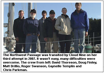
Gaynelle and the rest of our
Arctic crew were waiting for us at Halifax. We
were a crew of six. In addition to Gaynelle and
I we had Doug Finley and Chris Parkman from San
Francisco aboard, both of whom had been with us
on our 2005 attempt. Also aboard were David Thoreson
from Okoboji, Iowa and Matt Drillio from Halifax.
David had been with us on our 1994 attempt and
also on a passage to Antarctica in 1992. Matt
joined us as a replacement for a last minute cancellation.
Gaynelle had been busy prior to our arrival and
her hotel room was filled with enough provisions
to feed six people for 90 days in the Arctic.
 After
moving everything aboard and making a few last
minute alterations, Cloud Nine and crew left Halifax
on Gaynelle’s birthday, July 19. Our route
took us northeast along the south coast of Nova
Scotia, and passed through Bras D’or Lake
on Cape Breton Island traveling in fog much of
the time. Bras D’or Lake is about 50 miles
long and is unusual having a lock at the southwest
end and open to the sea to the northeast. Good
weather favored us as we departed the lake and
headed north in the Gulf of St. Lawrence. Much
to our surprise, we found ice in the Strait of
Belle Isle between Newfoundland and Labrador.
As we approached Cape Baud on the northeast tip
of Newfoundland, gale force winds overtook us
resulting in a hard night as we worked our way
into St. Anthony, our final stop before heading
to Greenland. After
moving everything aboard and making a few last
minute alterations, Cloud Nine and crew left Halifax
on Gaynelle’s birthday, July 19. Our route
took us northeast along the south coast of Nova
Scotia, and passed through Bras D’or Lake
on Cape Breton Island traveling in fog much of
the time. Bras D’or Lake is about 50 miles
long and is unusual having a lock at the southwest
end and open to the sea to the northeast. Good
weather favored us as we departed the lake and
headed north in the Gulf of St. Lawrence. Much
to our surprise, we found ice in the Strait of
Belle Isle between Newfoundland and Labrador.
As we approached Cape Baud on the northeast tip
of Newfoundland, gale force winds overtook us
resulting in a hard night as we worked our way
into St. Anthony, our final stop before heading
to Greenland.
After topping off fuel, water,
and picking up a few fresh provisions we were
ready to go again. Having waited as long as possible
to get the ice outlook before committing ourselves
to the passage, we now needed to keep moving.
Leaving St. Anthony the morning of July 26, we
saw several icebergs and soon ran into fog again.
The large icebergs usually show up on radar, but
the smaller ones and bergy bits do not, requiring
a careful watch in the fog. Starting on an easterly
heading before bending north we hoped to get through
the greater concentration of icebergs floating
south along the coastline carried by the Labrador
current. Although the bergs thinned out the second
day, the wind increased dramatically and we soon
found ourselves running before another gale. Our
only sail was a small jib, but we were moving
fast and making good progress. For several hours
we experienced exceptionally heavy rain, but eventually
the gale blew itself out and conditions improved.
 A
day later we were motorsailing due north in clear
calm conditions. One crew member saw a green flash
as the sun went down and we continued under a
full moon in the semi dark Arctic night. Later,
a brilliant display of northern lights made the
evening unforgettable. It is nights like this
that cause us to forget the unpleasant weather
and continue sailing year after year. A
day later we were motorsailing due north in clear
calm conditions. One crew member saw a green flash
as the sun went down and we continued under a
full moon in the semi dark Arctic night. Later,
a brilliant display of northern lights made the
evening unforgettable. It is nights like this
that cause us to forget the unpleasant weather
and continue sailing year after year.
Much of our passage to Greenland
was in fog, often heavy, but the light northerly
wind was not unpleasant. As we progressed north,
we started to experience difficulty with our e-mail.
Our mail comes in via high frequency radio making
it subject to high latitude propagation problems.
This was no surprise because 2007 was expected
to be a bad year for sun spot activity. For this
reason we carried a satellite telephone giving
us backup communication when needed.
On August 1st our headwinds
increased to 25 to 35 knots making for heavy going,
but we had not seen any ice since clearing the
Labrador coast. As we approached Greenland one
incident really got our attention. Gaynelle finished
dinner and went up on deck to relieve the watch
so they could come down and eat. She checked the
radar before going up and found it clear, but
only moments later, a large iceberg suddenly loomed
out of the fog directly ahead of Cloud Nine. Gaynelle
immediately took control from the auto pilot and
narrowly missed the berg. Moments later it disappeared
back into the fog again and careful examination
of the radar revealed no sign of it. This was
a dramatic warning that even large icebergs are
not always visible on radar.
 The
next day Cloud Nine crossed the Arctic Circle
at 66 degrees, 33 minutes north latitude formally
entering the realm of the Arctic and the beginning
of the Northwest Passage. The heavy weather with
fog continued and we were taking a lot of water
over the bow. It was cold, in the 30s at night,
and everyone was getting tired from fighting the
constant headwinds and the strain of the continuous
ice watch. Although planning to make our first
Greenland stop at Aasiaat, we decided to divert
to Sisimiut until the weather subsided. Perched
on rocky hillsides just north of the Arctic Circle,
Sisimiut is Greenland’s second largest community
with a population of about 5500. While waiting
for better weather, we had two days to explore
the town. Finally the north wind eased at which
time we were underway again. Encouraging ice reports
influenced us to skip Aasiaat and continue on
to Upernivik, about 350 miles to the north. For
most of this passage our weather was clear and
relatively calm. This was an unparalleled luxury
after the nearly constant fog and often heavy
weather that had accompanied us since leaving
Halifax. The
next day Cloud Nine crossed the Arctic Circle
at 66 degrees, 33 minutes north latitude formally
entering the realm of the Arctic and the beginning
of the Northwest Passage. The heavy weather with
fog continued and we were taking a lot of water
over the bow. It was cold, in the 30s at night,
and everyone was getting tired from fighting the
constant headwinds and the strain of the continuous
ice watch. Although planning to make our first
Greenland stop at Aasiaat, we decided to divert
to Sisimiut until the weather subsided. Perched
on rocky hillsides just north of the Arctic Circle,
Sisimiut is Greenland’s second largest community
with a population of about 5500. While waiting
for better weather, we had two days to explore
the town. Finally the north wind eased at which
time we were underway again. Encouraging ice reports
influenced us to skip Aasiaat and continue on
to Upernivik, about 350 miles to the north. For
most of this passage our weather was clear and
relatively calm. This was an unparalleled luxury
after the nearly constant fog and often heavy
weather that had accompanied us since leaving
Halifax.
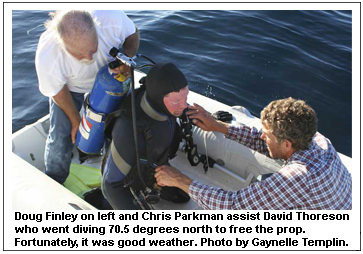
One afternoon at seventy and
one half degrees north latitude and several miles
from the Greenland coast, our engine RPM suddenly
dropped. It acted like a dirty fuel filter, but
that was not our problem. Rope particles in the
water suggested a fouled propeller. This was not
good news at this latitude, but fortunately it
was calm. We dug out our cold weather diving equipment,
put the dinghy in the water, and David volunteered
to go down. He found and cut away a heavy entanglement
of 1/2 inch polypropylene line. It was a relief
to be on our way again without a bent shaft or
other damage while David warmed up sipping hot
drinks.
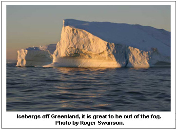
 The
weather remained placid, but at times we encountered
many icebergs. On one occasion we counted 79 bergs
all visible at the same time. Motoring through
these magnificent castles of ice is a humbling,
but an indescribably exhilarating experience. The
weather remained placid, but at times we encountered
many icebergs. On one occasion we counted 79 bergs
all visible at the same time. Motoring through
these magnificent castles of ice is a humbling,
but an indescribably exhilarating experience.
On August 6th we moored at Upernavik
and radar repair was our primary concern because
it had failed during our passage from Sisimiut.
Being well past the summer solstice, our 24 hour
daylight was gone. With a few hours of darkness
each night, we needed our radar. Fortunately a
fishing boat in the harbor was able to provide
us with an antenna rotation motor that seemed
to solve our problem.
Shortly after arriving in Upernavik,
another sailing vessel came into the harbor and
moored alongside us. Much to our surprise, it
was Jotun Arctic, the boat with whom we had spent
so much time while marooned by the ice of Franklin
Strait two years age. Not knowing they were in
the area, we could hardly believe this amazing
coincidence as they arrived. Her skipper, Knut,
explained that he was committed to a research
project in Greenland and would not be attempting
the Northwest Passage this year.
Ice reports told us there was
still a large concentration of pack ice in Baffin
Bay between Greenland and Canada, but by going
far enough north, we should be able to maneuver
around it. With fuel and water tanks full, Cloud
Nine was underway from Upernavik on August 8th
in clear weather picking her way through 20 miles
of icebergs and offshore rocks before reaching
open water. The bergs thinned out as we headed
northwest, but heavy fog soon set in lasting nearly
all 400 miles across Baffin Bay. Near the half
way point we encountered the northern edge of
the ice pack but worked around it reaching 74
degrees, 53 minutes north latitude, the northernmost
point of our entire trip.
 Finally
we were able to bend southwest toward Lancaster
Sound, still in fog. The routine continued with
our watchstanders staring holes in the fog looking
for ice. It was frequently necessary to alter
course to avoid the occasional berg. Fortunately
it was calm most of the time, but temperatures
were in the 30s, cold in the Arctic dampness.
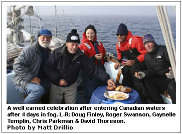
Upon reaching Lancaster Sound on August 11 we
had a party on deck using our fuel drums as cockpit
tables to observe our entry into the Canadian
Arctic. Later in the day the fog cleared and we
saw several white citadels floating nearby not
visible on our radar. We wondered how many we
had unknowingly narrowly missed in the fog. Finally
we were able to bend southwest toward Lancaster
Sound, still in fog. The routine continued with
our watchstanders staring holes in the fog looking
for ice. It was frequently necessary to alter
course to avoid the occasional berg. Fortunately
it was calm most of the time, but temperatures
were in the 30s, cold in the Arctic dampness.
Upon reaching Lancaster Sound on August 11 we
had a party on deck using our fuel drums as cockpit
tables to observe our entry into the Canadian
Arctic. Later in the day the fog cleared and we
saw several white citadels floating nearby not
visible on our radar. We wondered how many we
had unknowingly narrowly missed in the fog.
The ice disappeared as we proceeded
west in Lancaster Sound. Our radar failed again,
but the fault seemed unrelated to our previous
antenna problem. It was a glorious clear day as
we continued west in calm waters. Since our ice
reports told us that Franklin Strait was still
closed ahead of us, we decided to take a break
and anchor in Port Leopold on the northeast corner
of Somerset Island. This is a desolate bay and
a lone deserted house on the beach was the only
sign of previous habitation. Port Leopold is the
harbor where James Clark Ross wintered with his
two ships, Enterprise and Investigator, for 11
months during the winter of 1848-49 while searching
for evidence of the John Franklin expedition.
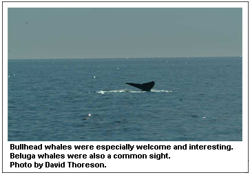
As we entered the bay we found it teeming with
Beluga whales. There must have been well over
a hundred Belugas spouting around the bay. It
was fascinating listening to them as we turned
in for the first good night’s sleep in several
days.The whales were still with us in the morning
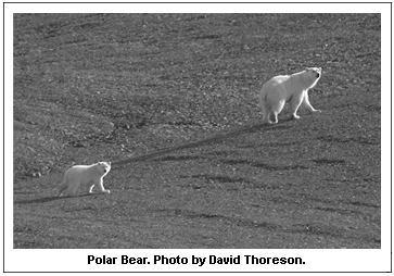
and we spotted three polar bears on the beach.
Four of our crew went ashore in the dinghy well
away from the polar bears, but carried our shotgun
just in case. On our trip two years ago, the Canadian
Coast Guard warned us to “Never, never,
never go ashore in the Arctic without a firearm”.
Soon underway, we proceeded west along the north
shore of Somerset Island in ice free water. This
was an almost unbelievable contrast to our '94
and '05 trip where we were completely blocked
by ice in this area for several weeks.
 Peel
Sound was also ice free as we headed south. We
chose a route along the east side of the sound
hoping we could see Bellot Strait and Camilla
Cove where we spent so much time in the ice in
'05. We were hand steering much of the time. The
auto pilot’s magnetic compass was not dependable
because of our close proximity to the north magnetic
pole. Our shipboard compasses were also nearly
useless for the same reason. Running blind in
the fog with no visual references, we could only
determine our course by referring to the GPS. Peel
Sound was also ice free as we headed south. We
chose a route along the east side of the sound
hoping we could see Bellot Strait and Camilla
Cove where we spent so much time in the ice in
'05. We were hand steering much of the time. The
auto pilot’s magnetic compass was not dependable
because of our close proximity to the north magnetic
pole. Our shipboard compasses were also nearly
useless for the same reason. Running blind in
the fog with no visual references, we could only
determine our course by referring to the GPS.
On August 15th a brisk following
wind carried us past Bellot Strait and Camilla
Cove, but the fog prevented us from seeing either
location. Ahead lay the Tasmania Islands. Until
two days ago our downloaded ice charts showed
pack ice blocking our passage beyond the islands.
Yesterday’s report showed a lead just starting
to open south of the islands along the east side
of Franklin Strait and Larsen Sound. But would
it stay open? In '05, just 30 miles north of here,
a lead very similar to this one had opened for
us. After starting through with Cloud Nine, it
closed again trapping us for nine days in Camilla
Cove.
As we approached the Tasmania
Islands, the wind eased and the fog cleared which
was a big relief with possible ice ahead. Once
in the lee of the Tasmania Islands we slowed and
waited until midafternoon for the updated daily
ice chart to come in via our satellite telephone.
When it became available, it appeared that the
lead would still be open. With the wind down and
fog free, conditions were ideal for passage. The
word was “Go” and we headed south
with all possible speed. Much to our relief, we
did, in fact, find the lead open. We followed
the eastern edge of Franklin Strait along the
west shore of the Boothia Peninsula and although
we could not see the ice to starboard, we knew
it was close by from our ice information. Pack
ice can only be seen if it is less that three
miles away because it lies low in the water in
contrast to the towering icebergs that can be
seen for many miles.
The next day in Larson Sound
we encountered an 11 mile ribbon of pack ice,
but were able to bypass most of it. Our next concern
was James Ross Strait which is a shallow shoal
and rock strewn area about 20 miles long. Amundsen
went aground in this strait in 1903 and nearly
lost his ship, Gjoa. Without ice and with the
benefit of GPS, we carefully passed through without
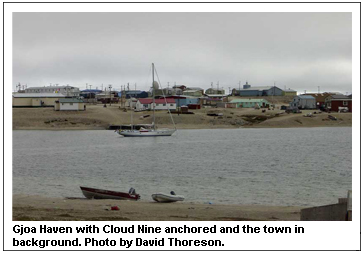
incident and continued on. Morning found us anchored
off the village of Gjoa Haven where Amundsen spent
two winters. It was August 17 and this was a major
milestone for us. I have been trying to get here
for 13 years!
Gjoa Haven is a quiet settlement
of about 1200 people, primarily Inuit. The small
hotel was closed and there were no restaurants,
but two grocery stores were open and seemed to
be the center of most social activity. I suspect
they don’t get many tourists, but everyone
was very friendly and made us feel welcome. Although
there were a handful of automobiles, four wheelers
seemed to be the principal means of local transportation.
We met two individuals who claimed to be direct
descendants of Amundsen; a grandson and a great
granddaughter. We wondered how many cousins they
had!
After spending a second day
in Gjoa Haven, we were underway at 0340 in the
morning of August 19 in light rain headed for
Simpson Strait. This is another passage requiring
careful navigation with many course changes to
avoid shoals. With relatively calm weather and
no threat of ice, all went well despite running
in fog much of the time. Next came Storis Strait
and Requisite Channel also requiring careful piloting,
but all went well. In Requisite Channel we met
and talked with Sir Wilfred Laurier, the Canadian
icebreaker we came to know two years ago. Sir
Wilfred was in the process of setting channel
markers in the narrow straits, but we had already
come through the difficult areas without them.
In Queen Maud Gulf we had to
tack through 20 to 25 knot winds directly on the
nose. We were all pretty tired when we eventually
reached the village of Cambridge Bay on the southeast
corner of Victoria Island. This was another major
milestone for us. We were finally able to meet
Peter Semotiuk who had been such a help to us,
both this year and in '05, relaying ice and weather
information via radio and satellite telephone.
He had good news for us. The new radar we ordered
had arrived in Cambridge Bay and was in the back
of his truck.
Peter had dinner with us aboard Cloud Nine that
evening and we learned he is an electronic technician
working at the North American Warning System installation
at Cambridge Bay. This is part of the updated
and very sophisticated surveillance system that
replaced the old Dew Line that was built in the
late 50’s to guard our northern frontier
during the Cold War. It was interesting to learn
that the Russian Bear is by no means dead and
there is periodic international sparring that
is seldom mentioned in our news.
Cambridge Bay was a little larger
than Gjoa Haven with a population of about 1500
and seemed more active. It apparently gets a few
tourists and occasionally an Arctic icebreaker
cruise ship. Stone carving is an important Inuit
art form and visitors give the artists a chance
to sell their work. In contrast to Gjoa, Cambridge
Bay has an operating hotel and a small gift shop.
A Wall Street Journal reporter was doing an article
on Arctic passages and spent several hours with
us. His article was printed on September 13 and
I was quite surprised to find my picture on the
front page of the WSJ. A friend noted that some
people pay their lawyers a lot of money to try
to keep their pictures OFF the front page of the
WSJ.
Our most important priority
was installing the new radar and we were relieved
to have it working again. Also important were
our first showers since leaving Greenland and
the availability of laundry facilities, much enjoyed
by all! After the usual shipboard maintenance,
plus replenishing fuel, water and a few provisions
we had Cloud Nine ready to go again. It was important
for us to hurry. Although the huge ice pack in
the Beaufort Sea north of Canada and Alaska had
been relatively stationary, several days of strong
northerly winds could move it south and block
our way ending our hopes of completing the passage.
Just before leaving Cambridge
Bay the English sailing vessel, Luck Dragon, arrived
in the harbor. We met her skipper, Jeoffrey, and
his crew briefly in Sisimiut and knew they were
also attempting the Northwest Passage. Their high
frequency radio was not working so they had not
been in contact with either Peter or ourselves,
but they had made good progress after leaving
Greenland a few days behind us.
Our next leg would take us about
600 miles along the south coast of Victoria Island
into the Beaufort Sea to Tuktoyaktuk in the Mackenzie
River delta. Much of the time we were in fog.
We experienced all kinds of weather, most of it
relatively good but were occasionally tacking
into strong winds with waves washing over our
coach roof bouncing us around a bit. Along the
route we saw several old Dew Line surveillance
stations. Peter had explained that some of these
were obsolete and abandoned, but others are active
using sophisticated new technology.
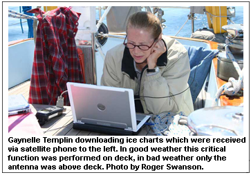 Gaynelle
downloaded an ice chart that showed the pack starting
to move south in Prince of Wales Strait between
Victoria and Banks Islands threatening to cut
off our route, reminding us to keep moving as
fast as possible which is exactly what we were
doing. Gaynelle
downloaded an ice chart that showed the pack starting
to move south in Prince of Wales Strait between
Victoria and Banks Islands threatening to cut
off our route, reminding us to keep moving as
fast as possible which is exactly what we were
doing.
One morning when I got up at
0200 for my watch, I was greeted with a cloudless
sky. It was dark, but the Arctic darkness is not
complete with the pink and red twilight along
the northern horizon. The full moon was visible
low in the southern sky. Because of all the fog
and cloudy weather we had not seen the moon at
any time since the last full moon nearly a month
ago. Varicolored northern lights flickered overhead.
Then a shadow started to appear on the upper left
portion of the moon. To our surprise, it was the
beginning of a total lunar eclipse that started
about 0230 and did not clear until well after
daybreak. I called the rest of the crew and we
were awed by the beauty of this nocturnal display.
Shortly before entering Tuktoyaktuk
on August 29 in the Mackenzie River delta we saw
several whales that we later learned were probably
Bowheads. Tuk was primarily a fuel stop with an
entrance channel over four miles long and only
12 feet deep. It is the major supply port for
the Mackenzie River and western Arctic area. With
the shallow water, supplies are generally transported
by barge. It was a little smaller, but otherwise
similar to the other Arctic settlements we had
seen.
The next morning we set our
clocks back two hours to Alaska time and were
underway toward Point Barrow, now about 500 miles
away. On August 31 we entered Alaskan waters and
discovered that Alaskan waters looked much like
Canadian and Greenlandic waters. FOG! Over our
VHF radio we could hear an Inuit hunting party
asking for assistance in towing a 34 foot whale
ashore. The indigenous Inuit people are allowed
to take a quota of certain whales each year and
this was causing a lot of local excitement.
About midway along the north
coast of Alaska strong easterly winds were predicted.
Easterly winds were good news and they arrived
quite rapidly in force at 0400 the morning of
September 1st. The following is a page from my
journal describing our conditions:
“Additional hands were
called on deck to put a second reef in the mainsail.
This was a challenge in the nearly dark Arctic
night with the temperature at 32 degrees and everything
wet from the mist and occasional rain. In order
to perform these operations, we had to work bare
handed in the biting cold. We completed the second
reef and furled the staysail as the weather increased.
With the wind off our stern we needed to wing
the jib to starboard on the spinnaker pole in
order to balance the rig. It is difficult to move
about in our heavy Arctic clothing, particularly
on the pitching foredeck with the boat rolling
and plunging in the heavy seas. We waited for
daybreak for this operation, at which time we
got everything in place and continued on. Wind
continued to increase and twice we reduced headsail
size by rolling in much of the jib. During the
late afternoon we furled the mizzen since it was
disturbing the airflow over the mainsail and also
causing us to round up. We were now averaging
over nine knots under gale force winds carrying
only a double reefed main and a scrap of poled
out jib through the day and into the next night.
We weren’t sleeping very soundly but were
making good time with Point Barrow less than 100
miles ahead.”
The winds held and carried us
past Point Barrow where we jibed and headed southwest
in the Chukchi Sea. The seas were running about
15 feet and occasionally one would wash into the
cockpit giving the crew a cold salt water bath.
With Point Barrow abeam to port and all ice threats
behind us, we all heaved a big sigh of relief.
It was September 2nd and our spirits were high
as the weather moderated and temperatures rose
as we continued south.”
As we passed Icy Cape we recalled
that this was the farthest north point reached
by Captain Cook during his third and last voyage.
From here he proceeded to the Sandwich Islands
(later called Hawaiian Islands) where he was killed
by natives. The Chukchi Sea is very shallow with
most of it being less than 150 feet deep which
was surprising to us.
On September 5 Cloud Nine and
crew, recrossed the Arctic Circle concluding our
transit of the Northwest Passage. This called
for a bottle of champagne to celebrate the occasion.
Our distance from the Arctic Circle going north
to the Arctic Circle going south was 3433 nautical
miles taking 34 days to complete. We knew we still
had a long way to go to reach Kodiak, but right
now we were feeling pretty good. After carefully
reviewing Northwest Passage statistics, as far
as we can determine, Cloud Nine is:
- The first American sailing
boat to complete the passage in one year.
- The first American sailing
boat to complete the passage from east to
west.
- The first boat of any flag
to make the passage east to west this year,
2007.
- At 76, I am probably
the oldest man to attempt this passage.
We didn’t realize that
the hardest part was yet to come.
Our next landmark was Cape Prince
of Wales, the westernmost point of the mainland
continent of North America. It is only 44 miles
across the Bering Strait to Siberia. Looking at
our longitude, it was interesting to note that
we were west of the Hawaiian Islands.
 The
next day we arrived in Nome just as headwinds
were starting to increase. The harbormaster had
the latest weather information and told us several
days of gale force southerly winds were predicted.
Since our course to our next destination, Dutch
Harbor on Unalaska Island, was almost 700 miles
due south, we had no reasonable choice but to
wait until the weather improved. The next several
days we listened to the strong winds howling overhead,
but were quite comfortable and secure behind the
large steel pier in Nome harbor. The
next day we arrived in Nome just as headwinds
were starting to increase. The harbormaster had
the latest weather information and told us several
days of gale force southerly winds were predicted.
Since our course to our next destination, Dutch
Harbor on Unalaska Island, was almost 700 miles
due south, we had no reasonable choice but to
wait until the weather improved. The next several
days we listened to the strong winds howling overhead,
but were quite comfortable and secure behind the
large steel pier in Nome harbor.
It was surprising to learn that Nome is experiencing
a new boom period. With gold topping $700 an ounce,
gold mining has become profitable again. Prospectors,
professional and nonprofessional alike, are infected
with gold fever. Hotels are completely sold out
and there is not a room available anywhere in
town. Old run down homes are being renovated and
everything livable is fully occupied.
With time on our hands, we saw
a lot of Nome. The sign said “There’s
No Place Like Nome” and we would agree.
In many ways it resembled a western frontier town
with more saloons than restaurants. Dancing girls
(strippers) from Anchorage were being imported
for weekend entertainment at one of the hotels.
Several homemade gold dredges were in the harbor
hiding from the bad weather outside. They were
rather fragile looking Rube Goldberg creations
but they apparently work well enough to find gold.
With a rented car we drove to the village of Teller,
about 70 miles north of Nome seeing many caribou
and musk oxen grazing along the highway.
Nome history is interesting.
Three Swedes found gold on nearby Anvil Creek
in 1898 and soon the rush was on. By winter the
news had reached the Klondike and by the following
year the tent city that miners originally called
Anvil City had a population of 10,000. The news
soon reached Seattle that gold was being found
on the beaches of Nome with no mountain range
to cross before reaching it. By 1900 the tent
and log cabin city had a population of 20,000
prospectors, gamblers, claim jumpers, saloon keepers
and prostitutes. Included was Wyatt Earp who established
the Dexter Saloon in Nome and is reputed to have
eventually returned to California with $80,000,
a nice nest egg for that day.
We waited in Nome for nine days
while successive low pressure cells moved north
up through the Bering Strait giving us gale force
southerly headwinds. On September 15 another huge
low was approaching, but it appeared we had a
two day window before it arrived. Hopefully this
would allow us to reach the island of Nunivak
about 275 miles south of Nome that afforded good
protection. Knowing that we weren’t going
to get through the Bering Sea without some punishment
we got underway the afternoon of September 15.
The headwinds kept us close
hauled all the way with mist and occasional rain,
but the wind seldom exceeded 25 to 30 knots. We
pushed as hard as possible hoping to make Nunivak
before the next low arrived. Two days later we
were quite happy to drop the anchor in a well
protected cove on the north shore of the Nunivak
Island anchorage just as the headwinds were becoming
strong.
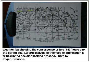
We spent two days waiting at
Nunivak while the large 965 millibar low moved
up through the Bering Sea northwest of us buffeting
the island with strong southerly winds. During
the afternoon of the second day the wind eased
a bit, but another low was forming following on
the heels of the present one. A possible shelter
between Nunivak and Dutch Harbor was St. Paul
Island in the Pribilof Group about 250 miles to
the southwest. It was still blustery, but we got
underway that evening hoping to get as far as
possible toward St. Paul before the next gale
arrived. Once clear of the lee of the island conditions
were pretty tough, but later the next afternoon
the wind eased enough so we were able to make
reasonable progress toward St. Paul Island.
As we approached the island a day later, our surface
analysis and text weather reports indicated we
could expect an exceptionally deep low and would
probably take four or five days to pass. This
was bad news but Gaynelle downloaded other wind
charts where it appeared we were on a ridge between
the two lows. This matched our present conditions
with moderate winds less than 20 knots. Rather
than wait at St. Paul, it looked like we could
head directly for Dutch Harbor staying between
the lows, making it most of the way before the
strong southwesterlies overtook us. If we were
caught before reaching our destination we could
heave to and ride it out at sea.
 This
looked like our best alternative and we altered
course for Dutch. That night the wind went light
and the following morning started filling in from
the north. We guessed right. By the time we reached
Unalaska Island the wind had backed to the southwest
and starting to pipe up, but on the morning of
September 24 we were safely moored in Dutch Harbor.
The Bering Sea was finally behind us and we were
quite happy to have bypassed St. Paul Island where
the gale was now really roaring. This
looked like our best alternative and we altered
course for Dutch. That night the wind went light
and the following morning started filling in from
the north. We guessed right. By the time we reached
Unalaska Island the wind had backed to the southwest
and starting to pipe up, but on the morning of
September 24 we were safely moored in Dutch Harbor.
The Bering Sea was finally behind us and we were
quite happy to have bypassed St. Paul Island where
the gale was now really roaring.
Next to us at the dock were
two vessels that are featured in the TV series
The Deadliest Catch about crab fishing in the
Bering Sea, namely Maverick and Far West Leader.
I suspect they were in port for the same reason
as ourselves, to escape the storm conditions outside
the harbor.
The history of Dutch Harbor
goes back to the 1700’s when the Russian
American Company made it their headquarters for
the sea otter fur trade. Their treatment of the
indigenous Aleut population was unbelievably brutal
as they forced them to deliver sea otter furs
to the traders. More recently, Dutch Harbor was
a major base in the Aleutians campaign during
WW II. The harbor was heavily bombed by a major
Japanese carrier task force in 1942. It was supply
port for the recapture of Attu Island in 1943
that resulted in the heaviest casualty rate of
any of the Pacific island campaigns with the exception
of Iwo Jima. Remains of pill boxes, gun emplacements,
and concrete bunkers in and around Dutch Harbor
reminded us of the German fortifications at Normandy.
Dutch Harbor was interesting
but our primary concern was finding a weather
break that would allow us to make the final 600
mile dash to Kodiak Island where Cloud Nine will
spend the winter. The wind had been blowing hard
in the harbor, up to 50 knots, as the low pressure
cell passed north of us. The good news was that
our course would be east northeast and the wind
should be on our backs
 When
the wind started to ease, it looked like we might
have another two day window that should get us
at least half way to Kodiak and we could take
shelter in the Shumagin Islands if necessary.
We left the evening of the 25th going through
Unimak Pass into the Gulf of Alaska. The second
night out the barometer started to drop and the
weather deteriorated. For about 36 hours we had
gale force winds including several hours of storm
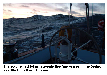
conditions of 55 to 65 with gusts to 70. During
the blow the seas reached 25 feet but fortunately
the wind remained behind us. Our only sail was
a reefed mizzen and a small jib. The downwind
ride was uncomfortable but it was rather exciting
on deck trying to steer the boat down the face
of the waves while trying to avoid a broach or
burying the bow in the short steep waves. In 46
hours the barometer had fallen 32 millibars. When
the wind started to ease, it looked like we might
have another two day window that should get us
at least half way to Kodiak and we could take
shelter in the Shumagin Islands if necessary.
We left the evening of the 25th going through
Unimak Pass into the Gulf of Alaska. The second
night out the barometer started to drop and the
weather deteriorated. For about 36 hours we had
gale force winds including several hours of storm
conditions of 55 to 65 with gusts to 70. During
the blow the seas reached 25 feet but fortunately
the wind remained behind us. Our only sail was
a reefed mizzen and a small jib. The downwind
ride was uncomfortable but it was rather exciting
on deck trying to steer the boat down the face
of the waves while trying to avoid a broach or
burying the bow in the short steep waves. In 46
hours the barometer had fallen 32 millibars.
As we approached Kodiak, the
wind dropped dramatically giving us comfortable
sailing conditions the rest of the way. About
1700 on September 29, Cloud Nine and crew moored
in the Kodiak Marina and our trip was over; 73
days and 6640 miles from Halifax. The total trip
from Cloud Nine’s starting point in Trinidad
on March 17 was 8925 nautical miles or 10,264
statue miles. It was a satisfying feeling to finally
tie up for the last time.
After arriving at Kodiak, we learned the sad news
that the English sailing vessel, Luck Dragon,
had to be abandoned at sea in heavy weather south
of St. Paul Island in the Bering Sea. The crew
was rescued by a fishing vessel and brought to
Dutch Harbor. The sailing boat sank a short time
later.
But for us it had been a good
trip with a good crew and we were all happy to
have finally completed our Northwest Passage transit.
We put Cloud Nine to bed in Kodiak for the winter
and one by one the crew members packed up and
headed home, with Gaynelle and I finally leaving
October 5th.
Roger Swanson is from Dunnell,
Minnesota. He has cruised Antartica twice, the
northwest passage three times and circumnavigated
four times. He has received numerous international
awards for cruising and seamanship. His wife,
Gaynelle Templin, has played increasingly larger
roles on their adventures. She completed her first
circumnavigation in 2006.
David Thoreson has sailed
seven times with Roger Swanson including twice
to the Arctic and over 35,000 nautical miles on
Cloud Nine. He has an interesting blog of the
trip on his website which is his professional
studio at: www.bluewaterstudios.com
For more photos visit the
Celebration Festival Pages in this February 2008 issue.
TOP
|