perform near Tulum, Mexico.
Cruising the Northwest Caribbean
Sailing The Yucatan Peninsula – Barrier Reefs and Coral Atolls
By Barbara Theisen
“Are we at Disney World or is this town for real?” I asked as we walked down the cobblestone streets of Isla Mujeres, Mexico. I had spent quite a bit of time in Mexico years ago but I had never come across a town quite like this. Quaint street after quaint street filled with small, neat stores selling every typical Mexican craft imaginable. There were Yucatan hammocks hanging from hooks, onyx chess sets, woven baskets, colorful serapes and sombreros, glass donkeys and leather huarache sandals. Sprinkled in between the vendors were outdoor cafes filling the quaint streets with the wonderful smell of traditional homemade Mexican food. Tourists zigzagged down the cobblestone streets in golf carts. And all of this was located on a tropical island surrounded by the stunningly clear turquoise waters of the Caribbean Sea.
|
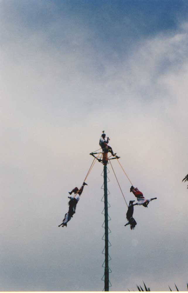
| The “Voleadores” or Mayan flyers perform near Tulum, Mexico. |
It all seemed rather fake – but like a very well done reproduction – like something Walt himself would have done. Surely this is exactly what every tourist imagined a quaint Mexican town to be like.
Or perhaps it was simply culture shock. We had just arrived from Cuba and the touristy atmosphere of Isla Mujeres overwhelmed us.
Out of Bounds had left Maria la Gorda, Cuba the previous day at noon. We headed out across the Yucatan Channel in light airs. Cruise ship traffic was abundant, although most were miles away from us.
We had a very easy crossing – the Caribbean was flat calm. The lack of a good breeze made us finally resort to motorsailing. The mighty Gulf Stream flowed northward causing us to head slightly south of our destination.
With our yellow quarantine flag flying, we put down the anchor at Isla Mujeres in early afternoon. The crossing to Mexico took us just over 24 hours. Tom immediately headed to town in the dinghy. Our customs information stated that only the captain was allowed ashore initially. Tom was loaded down with the necessary documents to clear into Mexico – boat’s documentation papers, our “zarpe” or clearance papers from our last port of call, crew list (six copies), passports, etc.
Our guidebook told us that first Tom would need to go to the Port Captain’s Office to get a temporary boat visa. The Port Captain would stamp and sign five copies of the crew list and keep one copy. Next Tom would need to go to Customs who would stamp the copies and keep one. Then on to immigration who will issue tourist cards and add more stamps to the crew list. Next a visit to the hospital for health clearance and more stamps. Finally Tom would have to go back to the Port Captain to show that he has all of the proper stamps on the crew list. I made sure he had his walking shoes on.
Unfortunately, when Tom arrived at immigration, he was told that he would have to go back to the boat and bring the girls and myself back to town. So he had to walk the couple miles back down to the dinghy dock and out to the boat he went. This time we all climbed aboard and headed back to town where we walked the couple miles back to immigration. The immigration officer had assured Tom he would be open until 4pm. We arrived at 2:45 to find the office locked up. But the neighboring storeowner said the officer would probably be back in awhile. At 4:30 we finally gave up and left.
Although we hadn’t officially finished clearing in, we couldn’t resist the lure of good Mexican food. We headed to an outdoor café where we enjoyed fresh tacos, queso fundido and enchiladas. Our family of four had a delicious dinner for around $3.00 total.
 |
| Kenna and Kate with a Voleadore in traditional dress |
The next day we finished clearing into Mexico. As in Cuba, we would have to clear into each port that we stopped in that had a Port Captain’s Office.
We had plenty of domestic chores to do in Isla Mujeres. We did banking, filled our propane tanks, provisioned, filled water and fuel tanks, caught up on laundry and enjoyed going into town most every evening for fresh, inexpensive Mexican food.
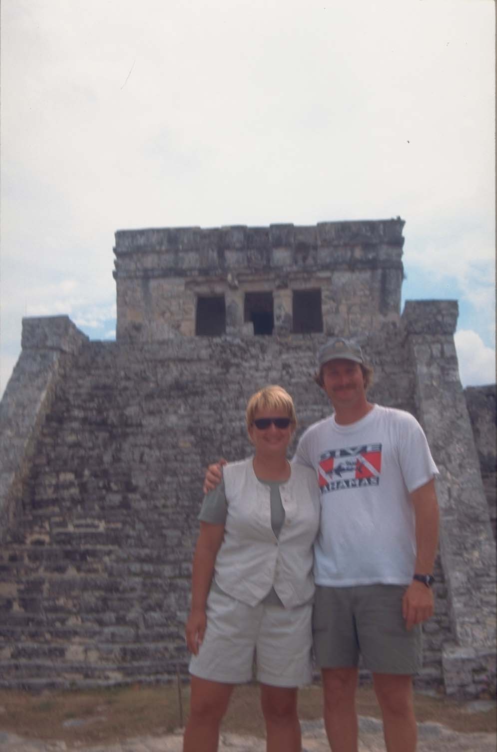 |
| Barb and Tom at the ruins of Tulum, Mexico. |
We also toured the island by golf cart, visiting some Mayan ruins. We celebrated Mardi Gras on the island. There was an afternoon parade followed by an evening of entertainment at the town plaza consisting of traditional dancing, music and fireworks.
Then it was time to head south down the Yucatan coast. We made several stops including one at the coastal town of Tulum.
Tulum was once one of the most important Mayan seaports. We could see the magnificent ruins standing on a 40-foot cliff as we approached. The “Castillo” once served as a lighthouse to guide boat through a tiny opening in the reef. Vessels drawing less than 7 feet could navigate the cut.
We sailed a bit further south where the entrance through the reef had a bit more water. All we had to do was locate some palms trees near a very tall casaurina tree that was south of the white cliffs that was south of the dock that is south of the lighthouse. Once we had that we could enter at a heading of 310 degrees and head towards the casaurina tree. We would need to spot the prominent rock that is awash and be sure to leave it about 100 yards to port. Easy!
We anchored Out of Bounds behind nothing but the barrier reef. This meant that we had nothing blocking the easterly winds, although the reef did do a fairly good job of breaking the waves. Still we found the anchorage a bit rolly. But we forgot all about that as we witnessed a magnificent blood red sunset behind the ancient ruins.
The next morning we headed to shore early trying to miss the busloads of tourists that we knew would be arriving from Cancun and other Yucatan resorts. We explored the ruins where Kate was especially impressed with the carvings of “diving god,” a Mayan deity that perhaps represents underwater diving. At least the scuba divers interpreted the upside down god that way.
At noon we headed into town. It was Wednesday; better know to the crew aboard Out of Bounds as “malaria Wednesday.” We were on our weekly doses of chloroquine, an anti-malaria medication. Every Wednesday we took our pill and every Wednesday we felt nauseous. We barely dragged ourselves through the jungle heat into town where we sat down in the cool plaza to watch the incredible Mayan “Voleadores” or flyers. We soon forgot all about malaria Wednesday as we watched these Mayan men, dressed in traditional costumes swinging upside down from a high pole, feet attached to a rope that unwound until they finally reached the ground.
On Thursday, as soon as the sun was high enough in the sky to provide good light for navigating the reef, we headed back out the cut and set our course for Bahia de la Ascension. This is a large bay that provides excellent protection. Little did we know as we entered through the reef, that we’d be hiding behind a little island in the bay here waiting out bad weather for a week as a norther blew down the coast.
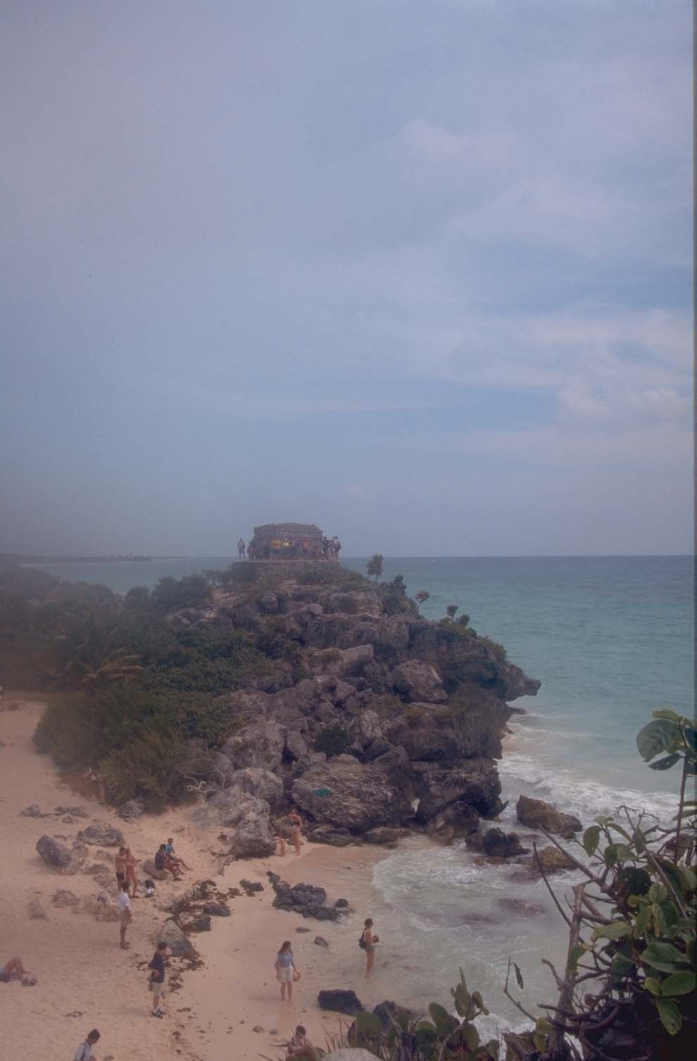 |
| Tulum ruins overlooking the Caribbean Sea. |
But it wasn’t a bad place to be stuck. The Sian Ka'an Biosphere Reserve, a protected natural area with miles of empty beaches, unspoiled rainforest and vast lagoons, is located here. The second largest protected area in Mexico, Sian Ka'an (which means 'where the sky is born' in Mayan) is home to hundreds of species of birds as well as peccaries, tapirs, alligators, manatees, iguanas, fish and sea turtles.
We finally found a weather window and escaped further south. We spent a night at Chinchorro Banks, one of four coral atolls in the western Hemisphere. Then it was on to the dusty town of Xcalak, the southernmost town on Mexico’s Yucatan coast.
The cut through the reef into Xcalak was narrow and once inside depths dropped to about 6-8 feet. We put down the anchor and headed into town to take a walk. Xcalak is a quiet town with dirt roads and palm tree lined beaches. A tourist boom is probably on the horizon as resort developments are quickly making their way south along the Yucatan coast of Mexico. I’m glad we got here before the crowds.
We needed to check out of Mexico before heading to Belize and Xcalak was the town where we could do this. Fortunately checking out of Mexico proved much easier than checking in. We only had two offices to visit and they were just down the beach from each other. We did have a pretty wild ride going out the cut at Xcalak. With large waves breaking all around us and the current coming in against us, it was a bit bumpy.
Next it was on to the town of San Pedro on Ambergris Cay in Belize. I was not looking forward to the cut into the reef at Ambergris, which is called San Pedro Pass. Seas were still fairly rough and the cut, which has depths of 9-10 feet, has a dog-leg turn in the middle of it to avoid hitting another reef. But Tom took us smoothly through and into the San Pedro anchorage where we found depths of about 7 feet over a sand bottom.
Checking into Belize was both easy and inexpensive. Kate, Kenna, Tom and I simply walked to the Police Station in town where we found Customs and Immigration.
San Pedro is a booming tourist town that has lost none of its charm. It is a laid back, barefoot kind of town. We enjoyed the beautiful beaches and the wonderful snorkeling on the reef. In town we went to both a Chinese restaurant and a Jamaican “jerk” restaurant. I even took advantage of this civilization and had a hair cut.
We provisioned at the only “real” grocery store we had seen since Isla Mujeres several weeks before. It was a modern supermarket and like everything in Belize, prices were about double that of the US.
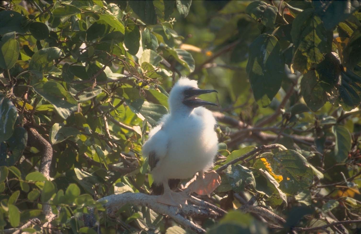 |
| Baby red-footed booby bird in nest in a ziricote tree. |
We loved Belize. We soon discovered the joy of sailing behind the barrier reef as well as the joy of diving the reefs. Belize has probably the best sailing of anywhere we have been. The winds are fairly consistent, blowing out of the east, which means you, can sail north or south down the coast on a comfortable reach. But the barrier reef, which extends along the entire coast of the country, blocks the seas. Sailing on flat waters in a brisk breeze was wonderful!
There is an abundance of cays that you can anchor behind although a good guide book, good light and the ability to read the water is needed to navigate in and out of these anchorages.
The highlight of our cruising Belize was visiting the coral atolls just offshore. Belize is home to three of the four coral atolls that are found in the Western Hemisphere. Coral growing around the edges of steep limestone plateaus formed the atolls. Inside this ring of coral is a lagoon.
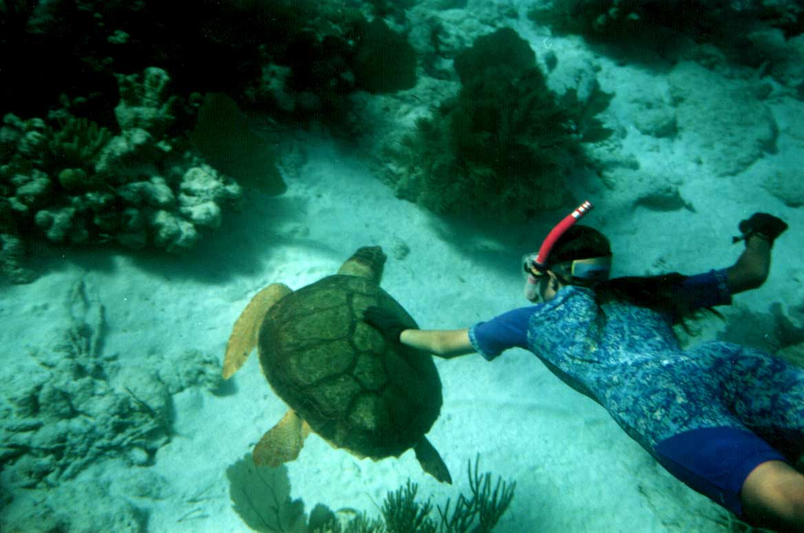 |
| Kate snorkels with a loggerhead sea turtle at Half Moon Cay Reef, Lighthouse Reef Coral Atoll, Belize. |
First we headed out to Turneffe Reef, just 8 miles off the barrier reef, where at a depth of 70 feet we could see the bottom! Turneffe is the largest of Belize’s coral atolls, stretching 30 miles long and 10 miles wide. We enjoyed dinghying up mangrove creeks and snorkeling the reef. Tom and Kate couldn’t get enough of the scuba diving, where visibility of over 100 feet is the norm.
From Turneffe Reef we sailed the 18 miles to Lighthouse Reef. Lighthouse Reef is the smallest of the coral atolls at about 25 miles long and less than 5 miles wide. There are five cays at Lighthouse and only three large breaks through the reef. But Lighthouse Reef is incredible!
Once inside the reef, we anchored just off of Half Moon Cay, which was Belize’s first Natural Monument, created in 1981. The lighthouse, which gives this coral atoll its name, is located on Half Moon Cay.
We couldn’t wait to get ashore and see the nesting red-footed booby birds. Half Moon Cay is home to a very unique colony of boobies. The adults here are white rather than the more common brown plumage of red-footed boobies.
Armed with binoculars and camera, we hiked the half-mile to where the Belize Audubon Society has built an observation tower. From there we could watch the boobies and the frigate birds soaring overhead and down to their nests in the beautiful red-flowering ziricote trees. But what fascinated us the most was the fuzzy white baby boobies.
The birds build their nest in November and lay eggs in December. The eggs hatch in January and February. We were there in late March. The baby boobies were incredibly fuzzy, large enough that they took up the entire nest and just getting curious enough to attempt stepping out onto a branch. We enjoyed their company for hours.
Equally fascinating is the underwater world at Lighthouse Reef. The snorkeling and diving are superb. Just off of Half Moon Cay we all snorkeled one afternoon over a glorious reef. The “viz” was unbelievable – clear water as far as the eye could see. We were visited by a sea turtle, saw lobsters and groupers of a size we’ve never seen before, we’re surrounded by gorgeous French Angelfish and were impressed by the variety and beauty of the coral we saw. I’ve snorkeled on some incredible coral reefs in the Bahamas and Cuba, but this was the most memorable snorkeling I have ever done. The kids had to drag me out of the water – I could have stayed forever.
From our anchorage at Half Moon Cay, we took a day trip to the famous Blue Hole, which is located at Lighthouse Reef about 7 miles north of Half Moon Cay. Kate and I were posted at the bow as Out of Bounds weaved its way around coral heads. Depths ranged anywhere from 10 to 20 feet but the coral patches rose to the surface without warning. We had good light, a necessity for this trip.
The Blue Hole is breathtaking. It’s a perfectly round hole filled with indigo blue water surrounded by a ring of coral broken by two narrow cuts. The Blue Hole is about 500 feet in diameter and is more than 450 feet deep. Jacques Costeau came here in 1972 with the Calypso to explore this unusual geological phenomenon.
As we entered the passage into the Blue Hole, we called out the depths “ten feet, twelve feet, 20 feet, no reading.” In a split second we went from 20 feet to hundreds of feet. We crossed the Blue Hole and went out the other passage where we moored to one of the dive balls that were located here – to protect the reef from damage from anchors. We were the only boat here. We could see absolutely nothing but water in any direction. It was an eerie feeling.
The Blue Hole itself is actually quite devoid of marine life. Scuba diving is limited to very experienced divers, as this is a decompression dive. As we snorkeled over the bottomless depths the only thing we saw were some beautiful squid. We headed over to snorkel around the ring of coral.
Along the reef, I spotted my first indigo hamlet, a fish I had picked out of our fish ID book as one of the fish I would someday like to see. Wouldn’t you know that my entire roll of film I took in my underwater camera that day was ruined. Fortunately I did get to show “my” indigo hamlet to Kate and Kenna so I have witnesses to my discovery.
As we dried off in the warm sunshine, we heard our first sign of human life. A floatplane circled overhead and then landed in the middle of the Blue Hole! It stayed there for just a few minutes and then headed out the cut in the reef and took off again.
By 2 PM it was time to start back. We would need good light to navigate our way home to Half Moon Cay.
We spent several more wonderful days at Lighthouse Cay anchored just outside the reef itself behind a cay. Kate and Tom went scuba diving every day doing wall dives while Kenna and I snorkeled the shallow coral reef. Evenings found us in the cockpit watching the magnificent sunsets and enjoying a cold beer. The weather was perfect, the view was magnificent and the company superb. We could have left the anchor down for a long, long time.
But we set sail for the Sapodillas – a group of cays along the southernmost part of Belize’s barrier reef where we spent several days and from there we went to the mainland of Belize and the town of Punta Gorda. Going ashore at Punta Gorda, we stepped onto the mainland of Belize for the first time – even though we had spent the past several weeks in the country. Checking out of Belize was as easy as checking in had been.
Back aboard Out of Bounds we set sail for the town of Livingston, Guatemala – the entrance to the famed Rio Dulce – only 16 miles away. Already the heat and humidity were upon us. We knew we were in for a big change. We’d be leaving the beautiful reefs and Caribbean blue waters of Belize behind and entering a world of freshwater rivers, rainforests, and mystery.
Barbara Theisen has spent the past ten years living aboard Out of Bounds with her husband Tom and daughters, Kate and Kenna. For more information on living the cruising life visit the Theisen’s Website at www.TheCruisingLife.com.