Sailing in Voyageurs National Park
by Jim Kimmet
|
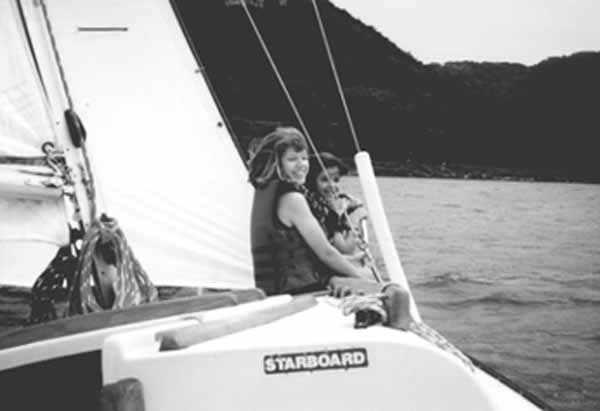
| Cally and Natasha enjoy the breeze in their faces as Blue Skies sails out across Lake Kabetogema. |
We arrived at the Kabetogama Visitor Center about 3 p.m. on Sunday afternoon and stepped out into a beautiful, sunny August afternoon overlooking Lake Kabetogama, glistening with dozens of pretty little pine-clad, rockbound islands. There was a pleasant breeze and as I began to drink in the beauty of our surroundings, Natasha and Cally, ages 14 and 11, asked “Where are the showers?”. In spite of the warmth of the sun a chill went up my spine and my heart stopped briefly as I envisioned our trip torpedoed right there in the parking lot. After a long pause, I pointed to the lake and replied “We have the whole lake”. In unison they responded “You said there would be showers!!”. I racked my brain for memories of such a rash statement but came up empty handed. Somehow that perilous moment passed without a mutiny, we loaded the boat, bought charts at the visitor center, and shoved off for our first anchorage in a cove at Deer Point Island.
I made dinner while the girls sat reading on a rocky outcropping, then we watched a fiery red sunset over the lake. After considerable reorganization of the cabin the girls went to bed and I sat out in the cool stillness of the evening and watched a zillion stars come out.
I chose Lake Kabetogama for this trip because my daughters had vetoed sailing in the Apostle Islands. Although I have sailed Blue Skies many times in the Apostles and I really wanted them to see the islands, the lighthouses, Manitou fish camp, and the sea caves, they felt that Blue Skies is just too small for Lake Superior. I chose Kabetogama specifically because it provides a wilderness sailing experience, yet it is very sheltered and satisfied their safety concerns.
Monday evening found us beating to windward in a drizzle through Squirrel Narrows towards Kettle Falls under full main and working jib. The breeze was steady, and on each tack Blue Skies turned smartly, heeled over, and accelerated. Cally came out and assisted me with tacking while Natasha read in the cabin. We were sailing among forests, rocks, wind and water and the feeling was wonderful. It was an odd feeling looking south into Canada, and it fit perfectly with the moment. The US/Canadian border runs down the middle of the channel, which is only about 100 yards wide in some spots, so we had to tack frequently and smartly to stay out of Canadian waters. About 7 p.m. we spotted the Kettle Falls dam, pulled over to a very nice dock, and found our way up the trail to the Kettle Falls Hotel.
The hotel, built in 1910 by a lumber baron and renovated in 1987, is part of the national park system and is only accessible by boat. Rooms were plentiful that day because the rain and gray weather had driven the fisherman away. After hot showers the girls played the piano in the lobby and we visited the bar to have a drink and check out the sloping floor which had been left unchanged during the renovation. It does add charm to the place but could cause problems for intoxicated fisherman or drunken sailors. We staggered a bit ourselves after having been on the water all day.
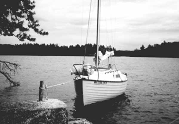 |
| Blue Skies at rest on the south shore of Mica Island. |
We spent part of the next morning relaxing and reading in comfortable chairs on the homey and spacious screened-in porch overlooking the pleasant hotel grounds, and then walked around to stretch our legs and hiked down to look at the dam. Marilyn, the hotel manager, told us about an abandoned mica mine on Mica Island. One of the staff hauled us and our gear down to the dock on a golf cart and had a wonderful sail on a broad reach upstream to Mica Island to visit the old mica mine. We found the post set in concrete on the south side of the island just as the hotel manager had described it. As we motored towards shore we dropped an anchor off the stern, maintained some tension on the anchor rode, nudged up to close to shore, and took a line from the bow to the post. By balancing the tension on the anchor rode and on the bow line the boat lay just a few feet offshore, but by pulling on the bow line the anchor rode stretched enough to allow us to get to and from the shore over the bow. We used this technique many times to get on to rocky shores without banging up the boat. It’s one of the advantages of a shoal keel/centerboard boat with a draft of 20 inches.
The remains of the mine were close by, and all that’s left is a hole in the ground with flakes of mica scattered around. The mine was started by W.R. Miller in 1895 during the gold rush but was only mined for one year. The mica was used as isinglass in lanterns and stoves. There wasn’t much to see, but standing there in the cool shade of the forest thinking about the effort and risk involved in traveling out here and mining 105 years ago, I felt an incredible sense of awe. Going without showers for a few days seemed awfully trivial. As we were hiking around the island a strong wind came up and we nervously rushed back to the boat. Blue Skies was lying beam-to the wind and being forced up towards the rocky shore, but the anchor held and we were able to board and cast off without damage.
Many people consider a 17 foot boat too small to sleep three people, but compared to tent camping I find it relatively luxurious. On this trip Natasha and Cally shared the V-berth and I took the quarter berth, and excess gear that occupied the quarter berth by day went on the cabin sole at night. The biggest challenge was toilet facilities. Blue Skies was originally equipped with a toilet and holding tank, but it took up an inordinate amount of storage space and was pretty useless at night because it was under the V-berth, so I took it out. I keep a Little John and an ice cream bucket lined with a plastic bag and filled with kitty litter on board, but the girls usually preferred to pull over to a campsite and use the latrine. Perhaps they would have changed their minds if the mosquitoes had been more prevalent.
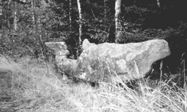 |
| One of many curious sculptures at Ellsworth Rock Gardens. |
On Thursday, back on Lake Kabetogama, we arrived at the dock at the Ellsworth Rock Gardens on the north shore of the lake just east of Cutover Island. Jack Ellsworth, a retired Chicago contractor, and his wife Elsie spent their summers here and built the gardens from 1944 to 1965. In this wonderful setting overlooking the lake there are 150 rock sculptures on a series of terraces. There are a whale, various stone tables, some with chairs, and other abstract shapes that Jack and Elsie hauled up and mortared into place. They also planted gardens of 28 different flower varieties, including 13,000 lilies, mostly long gone at this point. Sitting quietly in this peaceful setting one can imagine Jack and Elsie relaxing and enjoying the view over the lake after a sweaty day moving and mortaring rocks. Although the rock gardens have fallen into some disrepair, they are still well worth a visit. The park is in the process of evaluating the site and obtaining funds to undertake a full restoration.
We had a pleasant sail among rocky picturesque islands to a resort on the south side of the lake so that the girls could take showers, then out to Sugarbush Island to watch another sunset and anchor for the night. As we had done at Mica Bay and Bluefin Bay, we went ashore to a vacant campsite to cook and eat dinner. The single burner butane stove on Blue Skies is easily taken ashore for cooking.
By Friday the girls had had enough sailing, so we had another relaxing sail among sun-drenched islands to the launching ramp, pulled the boat, and drove to the Tower/Soudan iron ore mine for a tour, which I highly recommend.
Lake Kabetogama has possibilities for several different types of sailing experiences. One could cruise and stay on the boat, as we did, and travel as far as Crane Lake. One could stay at a resort and day-sail, or carry camping equipment and camp. There are large, luxurious houseboats for rent that usually have a fishing boat in tow, so take your day sailor or dinghy in tow. The waters are warm and the fetch of the lake is not great, so sailing an open boat is a reasonable way to go. Be sure to visit the Kettle Falls Hotel and the Ellsworth Rock Gardens. If you have the time, spend a few days on Kabetogama and then head up to Rainy Lake or Lake of the Woods. And, of course, bring your fishing gear.
Launching, Lodging, and Logistics
Lake Kabetogama is located in Voyageurs National Park about 300 miles north of Minneapolis and 15 miles east of International Falls. Lake Kabetogama connects to the much more well-known Rainy Lake just to the north, but unfortunately there is a dam in the way. It also connects directly to Namakan Lake, then Sand Point Lake, and finally to Crane Lake. There should be good sailing on Namakan Lake, but much of the lake is in Canadian waters so a visit to Canadian customs would be a good idea before sailing this lake. Canadian customs services are available at the Crane Lake Public Landing and at the International Falls Bridge.
There is a good launching ramp available at the Kabetogama Visitor Center just a few miles off Hwy 53. Call them for a park brochure and more information on park regulations (218-845-2111). A portion of the shoreline of Lake Kabetogama is outside the park and there are a number of resorts there (www.kabetogama.com or call the Kabetogama Lake Association at 800-524-9085), so a person could stay at one of the resorts and day-sail. Other entry points include Chief Woodenfrog State Campground and the Ash River Visitor Center on located on the narrows between Lakes Kabetogama and Namakan. Lodging is also available at the Kettle Falls Hotel (888-534-6835). The hotel also has very nice cabins available overlooking the rapids downstream from the dam. There is an excellent dock at the hotel.
There are many campsites which feature picnic tables, fire rings, and latrines. Some of the campsites are reserved for tents and some for houseboats, so be sure to review the park regulations before spending the night at a site. Some of the sites have docks.
Kabetogama is about 12 miles long and about 4 miles across at its widest point and there are lots of islands and bays to provide shelter and anchorages during inclement weather. You’re never more than a mile from an island or shore. Weather reports are available on VHF radio, and park rangers monitor Channel 16. Routes through the connecting narrows and major routes across the lakes are well marked with buoys that are easy to follow.
Outside the buoyed routes charts and some navigation skills are required to avoid submerged rocks which are marked on the charts. If you plan to traverse the narrows between lakes a motor is essential because the shoreline blocks the winds.
Jim Kimmet is a sailor, writer, engineer, and sailing instructor based in Plymouth, MN. Look for his forthcoming book, “Trailer Sailor’s Guide to the Northern Hemisphere”, in about a decade.